Nature takes precedence on this countryside route


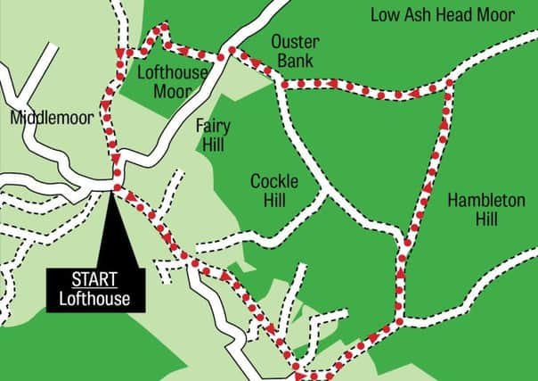
The walk is a lovely round one of about nine miles from Lofthouse which begins by following the valley floor to Low Sikes before steadily climbing to the hamlet of Bouthwaite.
After the hamlet a good track leads up to the moors which are enjoyed for five miles before the descent back into the Nidderdale valley from Lofthouse Moor.
Advertisement
Hide AdAdvertisement
Hide AdLook out for some interesting rock outcrops on the walk including two named after a mother and daughter.
The route
After parking up in Lofthouse, begin by following the Nidderdale Way eastwards towards Low Sikes.
You come to a point beside the River Nidd. From here the river heads down to meet Ramsgill Beck and flows into Gouthwaite Reservoir. Climb a bank towards Longside House.
On reaching Longside House, soon afterwards you arrive at Longside Farm and soon after that the quaint isolated hamlet of Bouthwaite.
Advertisement
Hide AdAdvertisement
Hide AdThe village sits just above the valley bottom of Nidderdale and has lovely views across towards Ramsgill and Gouthwaite Reservoir.
From Bouthwaite, begin the long steady climb to Fountains Earth Moor by following a good stone track.
It is a steady haul up the bank, 150 metres of ascent in a mile of walking to reach the first moor plateau at 310 metres elevation where you take a course due north and parallel with Lul Beck to the left.
Follow the course of the Six Dales Trail to the heart of Fountains Earth Moor and Sype Land.
Advertisement
Hide AdAdvertisement
Hide AdEyes are drawn straight ahead to a level stretch of rock outcrops on the distant horizon beyond the heather. This is Sypeland Crags. There is another smaller outcrop you walk besides, namely Lulbeck Crags. Near Sype Land take the right hand gate of two (the left hand gate takes you nearer Sypeland Crags).
After clearing the gate, walk steadily up towards a higher plateau of moor by following a course beside Lul Beck. After almost a mile you come to Lulbeck Crags, an interesting group of grit stone outcrops.
Continue on towards Lulbeck Head and Combs Fell.
Take a sharp turn left and from heading north you are now heading west across Combs Fell. This is the highest point on the walk and with the height the views are at their most distant.
You are now in the same vicinity as Jenny Twigg and her Daughter Tib, two rock sentinels on Sype Land which overlook Upper Nidderdale.
Advertisement
Hide AdAdvertisement
Hide AdWalk from Combs Fell and close to the trig point on Ouster Bank before crossing over the Lofthouse to Leighton road and heading on a slight uphill gradient to Thrope Edge.
As you walk from the track to the edge, Upper Nidderdale is unveiled in all its glory. You can see the sweep of the fledgling valley as it turns from west facing to north facing, a sweeping right angle centered around the area of the famous Manchester Pot and Goyden Pot, just two of a series of pot holes which attract many underground explorers.
After taking in the views, start the descent back into Nidderdale. It begins beside the ornate shooting hut on Thrope Edge, first as a steep winding course on a path through bracken and heather and then on an easier gradient near Thrope Plantation.
At Thrope Farm, the gradient levels off from descent to follow Thrope Lane.
Advertisement
Hide AdAdvertisement
Hide AdThe walled section of Thrope Lane gives way to open path after Thrope Plantation is cleared. As you continue walking you can hear the River Nidd making its way down the valley.
Into the final mile, nature takes precedence.
One moment you are walking in wild country and the next you are back on the tarmac road in Lofthouse.